
Atmospheric Anomaly: France Records Its First Pyrocumulonimbus Cloud as Extreme Wildfires Compound

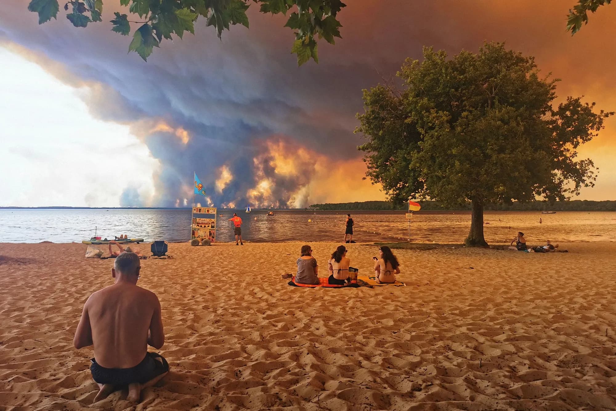
In recent years, the consequences of extreme heat and prolonged drought have reshaped ecosystems across the globe, bringing atmospheric phenomena that were once considered rare anomalies into mainstream meteorological study. In a striking milestone for European climate observation, France has officially recorded its first-ever pyrocumulonimbus cloud. Born from intense heat and thermal updrafts generated by unprecedented wildfire activity, this massive, fire-infused thunderstorm cloud represents a profound shift in how surface blazes interact with the surrounding atmospheric column.
While pyrocumulonimbus events have historically been documented in vast, fire-prone wildernesses such as the boreal forests of Canada, the Pacific Northwest of the United States, and the drought-stricken bushlands of Australia, their emergence in Western Europe underlines a changing climate dynamic. When extreme heat on the ground generates sufficient vertical energy, fires cease to be merely surface disasters—they begin to generate their own weather, compounding the hazards faced by emergency responders and nearby communities.
Anatomy of a Fire-Driven Thunderstorm
A pyrocumulonimbus cloud, often referred to by meteorologists as a pyroCb, is essentially a fire-generated cumulonimbus cloud. It forms when an exceptionally intense surface fire produces extreme radiative heat, driving a violent, super-heated column of air upward through the lower atmosphere. As this rising convective plume ascends, it carries vast quantities of smoke, ash, water vapor, and particulate matter into cooler high-altitude air masses.
As the moist air and ambient atmospheric water vapor cool at higher altitudes, condensation occurs around the abundant aerosol particles within the smoke plume. This rapidly builds high-altitude convective structures that closely resemble traditional thunderstorm clouds, complete with anvil-shaped tops that can reach into the upper troposphere and even breach the lower stratosphere. However, unlike typical meteorological thunderstorms driven by solar heating or cold fronts, pyroCbs are entirely powered by the intense thermal energy released by biomass combustion below.
Historic Conditions on the Ground in France
The formation of France's first recorded pyrocumulonimbus cloud was driven by a conjunction of extreme meteorological and environmental variables. Months of below-average precipitation, coupled with consecutive record-breaking heatwaves across Western Europe, left vast expanses of timber, shrubland, and agricultural terrain severely depleted of moisture. When ignition occurred, these super-dried fuels burnt with exceptional radiative intensity.
As wildland fires reached critical mass, the immense thermal energy output rapidly escalated. Standard wildland fires typically release heat that dissipates within the atmospheric boundary layer. However, under these record-smashing conditions, the fire front produced enough thermal energy to breach stable atmospheric layers, generating atmospheric buoyancy capable of lofting giant smoke columns tens of thousands of feet into the sky. The result was a dramatic cloud structure visible from space, marking an unprecedented chapter in France's modern fire record.
Self-Amplifying Environmental Hazards and Feedback Loops
The development of a pyrocumulonimbus cloud is particularly dangerous because it creates a hazardous feedback loop that exacerbates conditions on the ground. Once a pyroCb matures, it is capable of generating localized microbursts, erratic wind shifts, and intense lightning strikes. Because these clouds often form in extremely dry ambient air masses, much of the moisture within the cloud evaporates before reaching the ground—a phenomenon known as dry lightning.
When cloud-to-ground lightning strikes without accompanying rain, it can ignite secondary blazes miles ahead of the main fire perimeter, trapping firefighting crews and spreading the destruction across wider geographic zones. Furthermore, severe downburst winds emanating from the collapsing cloud tower can push oxygen back into the flame front, accelerating fire spread unpredictably. On a global scale, pyroCbs act as atmospheric elevators, injecting dark carbon soot and aerosols high into the stratosphere where they can persist for months, altering regional radiative balances and atmospheric chemistry.
Monitoring PyroCbs with Satellite Systems and Data Science
Detecting and analyzing pyrocumulonimbus events requires sophisticated Earth observation systems, combining real-time remote sensing with advanced atmospheric modeling. Space agencies and weather services monitor these events using geostationary and low-Earth orbit satellites equipped with multi-spectral imagers and infrared sensors. By evaluating thermal anomalies on the surface alongside cloud-top brightness temperatures, algorithms can differentiate standard smoke plumes from fully developed pyroCbs.
For data engineers and software developers working in environmental technology, processing these massive satellite data feeds presents a significant computational challenge. High-resolution telemetry must be ingested, normalized, and analyzed in near-real-time to provide emergency operations centers with situational awareness. Machine learning models trained on atmospheric soundings, smoke optical depth, and infrared surface heat signatures are increasingly utilized to predict when a surface wildfire possesses sufficient convective energy to transition into a pyroCb event.
A Shifting Reality for European Climate Resilience
The recording of a pyrocumulonimbus cloud in France signals that extreme fire dynamics are no longer confined to traditionally high-risk global regions. Western European countries, whose forestry management strategies and disaster response infrastructure were largely built around temperate climate profiles, must now adapt to high-intensity atmospheric fire behaviors. The shift demands broader cross-border coordination, enhanced atmospheric monitoring networks, and updated safety protocols for wildland firefighters.
Civil protection agencies are recognizing that predicting fire behavior now requires analyzing high-altitude meteorological data alongside traditional ground metrics like wind speed, humidity, and fuel moisture. As atmospheric instability increases alongside rising global temperatures, the frequency of extreme convective fire events is expected to grow, making deep integration between meteorological science and wildland disaster response critical.
Building Predictive Tools and Future Preparedness
To mitigate the impacts of these evolving hazards, software developers, climate scientists, and emergency responders are actively building next-generation disaster management platforms. Modern predictive engines combine numerical weather prediction models with physics-based fire propagation engines, allowing specialists to simulate how a fire's thermal release might interact with local atmospheric instability hours before convective clouds materialize.
Additionally, real-time alert systems powered by edge computing and automated drone surveillance are being deployed to monitor remote fire fronts, tracking humidity drops and thermal acceleration instantly. By supplying commanders with predictive atmospheric risk scores, these digital tools aim to provide early warnings before violent dry downbursts or lightning strikes compromise frontline containment efforts.
Adapting to an Era of Extreme Weather Events
The historic documentation of France's first pyrocumulonimbus cloud serves as a clear indicator that surface ecological crises can rapidly translate into complex atmospheric events. As severe heatwaves and prolonged droughts continue to redefine seasonal weather patterns, the boundary between terrestrial natural disasters and atmospheric weather generation is blurring.
Addressing this new operational reality requires a unified approach combining environmental science, advanced computing, and proactive infrastructure resilience. By leveraging high-resolution satellite arrays, automated telemetry pipelines, and sophisticated predictive models, the global technical and scientific community can better anticipate these dramatic atmospheric feedbacks, safeguarding communities and ecosystems in an era of unprecedented environmental change.
Source: wired.com